Grammar, bitchez!
A summary of the Morphing/Postmodern narrative:
"No wreckage has yet to be recovered."
Says it all, doesn't it?
What happened to
this data (Lea Gabrielle at 01:22 )?
The Way Point on the northwet side of her screen is "IGREX" on Jet Route "P628" where the heading changes to a more northerly direction 320 degrees to PORT BLAIR Navaid.
That's a total airborne time of about 4 hours 40 minutes from takeoff.

The arc graph shows the estimated range of the aircraft with it's remaining fuel IF it was flying at its MAXIMUM SPEED or 7 hours 30 minutes of fuel.
Now, from the article:
this statement towards the end of his article." A satellite was able to pick up a ‘ping’ from the plane until 08:11 local time,more than seven hours after it lost radar contact,
although it was unable to give a precise location.
Mr Razak went on to say that based on this new data, investigators ‘have determined the plane’s last communication with a satellite was in one of two possible corridors –north from the border of Kazakhstan and Turkmenistan through to northern Thailand,
and south from Indonesia to the southern Indian Ocean. "
That's
7 hours and 31 minutes after takeoff.
"... The plane departed for an overnight flight from Kuala Lumpur to Beijing at 12:40 a.m. on March 8.
Its communications with civilian air controllers were severed at about 1:20 a.m., and the jet went missing ... "
That leaves
2 Hours 50 minutes to travel from "IGREX" on Jet Route "P628 to an undefined point on that arc of 7 hours 30 minutes from takeoff.
Let's say that the pilot leans the engines out to get the most out of his fuel for distance with the remaining time for "IGREX" and gets 3 hours if time,
before he hits his 20 minutes safety margin on fuel and then starts to burn his 1 hour emergency fuel.
At maximum speed of Mach 0.89 (590 mph, 950 km/h, 512 knots) at a cruise altitude of 35,000 ft , that would
allow him 1770 miles of distance (to the red arc), before hitting his reserves.

Gen. McInerney said Allama [ Iqbal International ] Airport was the same distance from Malaysia Airlines Flight 370 point of departure, Kuala Lumpuras, its original destination airport, Beijing, China.
Gen. McInerney also said that if Pakistan didn't speak up soon, they would be complicit.
Now I ask you, if you heard another large jet land at an International Airport that had on average
4 other arrivals all around the same time, would you suspect anything out of the ordinary ?
I just want to inform you that arrivals make a lot less noise than
departures.
Also, from an air traffic controller's point of view, there ARE PROCEDURES for clearing a "RADIO OUT" or "NORDO" aircraft to land, and once the aircraft is safely down, it's up to the Airfield Base Operations Officer and the Fire Chief as to how to handle it.
They would probably have to fuel to refuel the 777 with little or no extra coordination.
Now take a close look at the arc map below, three graphics down and center.
Notice that Pakistan is within the "1 Hour Emergency Fuel Range" (second circle around the red arc), past the "20 minute safety fuel (first circle around the red arc).
So it meets the criteria of being within the Red Arc "handshake" or the last ACARS Satellite "ping" and within fuel range of the Boeing 777 to Allama Iqbal Int'l Airport, Pakestan.
It sounded like Gen. McInerney was all but threatening Pakistan to own up to it now, or suffer the consequences.
 Someone sent me another piece of information
 you should read.
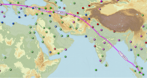
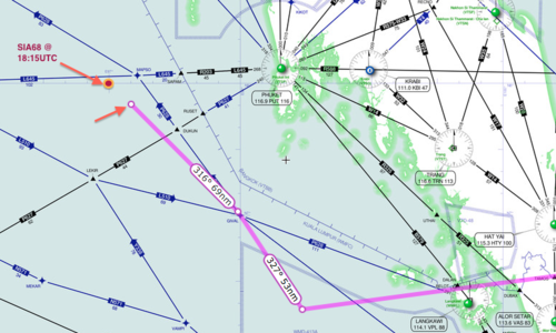
" Someone on another thread posted a link to a theory that the missing 777 used SIA68 (Singapore Airlines flight 68) to cloak their own airplane until they could get across the Indian Ocean, away from primary radar.
http://keithledgerwood.tumblr.com/post/79838944823/did-malaysian-airlines-370-disappear-using-sia68-sq68 "
That's a really good theory.
But there's problems when you try to match it with the
the arc graph (click on it for more detailed info) that shows the estimated range of the aircraft with it's remaining fuel IF it was flying at its MAXIMUM SPEED or 7 hours 30 minutes of fuel.
Now, from the article:
this statement towards the end of his article." A satellite was able to pick up a ‘ping’ from the plane until 08:11 local time,more than seven hours after it lost radar contact,
although it was unable to give a precise location.
Mr Razak went on to say that based on this new data, investigators ‘have determined the plane’s last communication with a satellite was in one of two possible corridors –north from the border of Kazakhstan and Turkmenistan through to northern Thailand,
and south from Indonesia to the southern Indian Ocean. "
My problem is ~ I don't know how accurate that Red Arc map is,
and I don't know whether to trust it or not.
Now another point, and PLEASE, PLEASE, tyake a look at the linked sources.
Take a close look at
this graphic.
In the world of Air Traffic Contgrol,
"Attention To Detail" is everything.
Being accurate FIRST is everything.
Being safe is everything.
Speed comes later, but accuracy is a must.
Now for other career fields, accuracy isn't stressed as much.
Now let's ASSUME that, in the speed of getting out the information, that graphic is built on the WRONG degree off of that satellite.
Look what that would do to the search area.
What if a Muslim sympathizer was in the chain of people that disseminated that information.
And take a look at the fuel capacity of the different models of
Boeing 777-200,
Maximum Fuel Capacitycan be from 31,000 U.S. gal (117,340 L) to 45,220 U.S. gal (171,170 L) to 47,890 US gal (181,283 L), depending on the configuration,
and that can give it a Maximum range (
at maximum payload {because MH370 might have weighed less, giving it a LONGER range} ) of from
5,240 nautical miles (9,700 km, 6,027 miles) to 7,725 nmi (14,310 km, 8,892 mi) to 9,380 nmi (17,370 km, 10,793 mi), depending on its configuration.
So the search area may change,
but since we don't know the exact configuration of that particular aircraft,
and we don't know if the Malaysia Officials are revealing ALL of the facts to us, or being honest with us,
we must assume the worst.
It took quite a bit of time to put it together.


Gen. McInerney on the phone with Uma Pemmaraju on America's News HQ at 12:06 Central Time, said he thought the Pakistan Air Force had helped MH370 get into Pakistani Air Space.
PAF Base Mushaf (formerly PAF Base Sargodha) (IATA: SGI, ICAO: OPSR) It has two runways measuring 10,000, and 7,700 feet respectively and a large hanger.
PAF Base Masroor (ICAO: OPMR) is the largest airbase operated by the Pakistan Air Force It is stated to have a single runways measuring 10,000 feet and a parallel taxiway that could be used for emergency landing and recovery of aircraft.
But look for yourself and see that it appears to have 2 long runways and several large hangers.
PAF Base Shahbaz (IATA: JAG, ICAO: OPJA) It is a military base operated by the Pakistan Air Force as well as a civilian airport.
It has a single runways measuring 10,000 feet and some large hangers.
PAF Base Rafiqui OPRQ It has a single 10,000 foot long runway and a parallel taxiway that could be used for emergency landing and recovery of aircraft.
I noticed one large hanger.
PAF Base Peshawar OPPS It has a a 8,900 foot long runway.Not to be confused with Peshawar Air Station.
It is … located immediately to the east of Peshawar International Airport, which is shared by civil aviation flights and military flights.
PAF Peshawar has an 8,900 foot long runway. It has one large hanger.
Peshawar Air Station was located in Badaber, a remote area about 4 miles (6.4 km) south of the city of Peshawar, Pakistan.
Peshawar Air Station is a former Central Intelligence Agency[1]-United States Air Force Security Service listening post, used by the 6937th Communications Group from 1958 until January 7, 1970, when the facility was formally closed.
Currently, the base is housed by Pakistan Air Force and is known as PAF Camp Badaber.
PAF Base M.M. Alam OPMI use to be PAF Base Mianwali and it has a 10,000 foot long runway. There is a parallel taxi way that could serve as an alternate runway in emergencies.
It also has a large hanger.
PAF Base Minhas OPMS has a 9,950 foot long runway.
But their is a parallel taxi way is marked as Runway 30R that could serve as an alternate runway in emergencies.
It has several large hangers, and a large camouflaged and extra long hanger south of Rwy 30 approach end and East of the exiting taxiway.
PAF Base Samungli OPQT has a single 12,010 foot long runway and a parallel taxiway marked as 13R/31L.
It has a large hanger and is also listed as Quetta Samungli Airport (UET).
PAF Base Nur Khan Airbase Chaklala renamed as Nur Khan Airbase and is part of Benazir Bhutto Islamabad International Airport OPRN
It's runaway is 10,809 x 150 feet and it has an intersecting taxiway that could be used for a runway (approximately 270/090 headings).
It has several large hangers and some have camouflaged roofs.
PAF Base Faisal OPSF Runway 08/26 approximately 8,000 ft (2438 m SkyVector World VFR) with several large hangers. some with camouflaged roofs.
Pakistan Air Force Academy is also know as OPRS - Risalpur Air Base.
It has two runways, Rwy 09R/27L is 9,085 X164 Ft of ASP, and Rwy 09L/27R is 5,840 X 164 Ft of ASP.
It also has a narrow parallel taxiway, and one large hanger.
I think they are simply "giving up ...".
MORE:
They're simply making their own best guess.
Industry expert says pilot took Malaysian plane to 43,000ft, causing oxygen to run out, as suicide becomes likely cause of crash
"Oxygen masks not enough to keep passengers conscious"
but doubts remain:
Reporternews.com: China demands Malaysia turn over satellite data
ClickonDetroit: Calls for har evidence on MH370's fate
BBC: "I'll consider my resignation later"
"The CEO of Malaysia Airlines says his possible resignation is "a personal decision" that he will consider "later". Ahmad Jauhari Yahya told the BBC he would not be stepping down any time soon..."
TheStandard.com: No confirmed debris, no closure for families
Globe & Mail: Mourning families lash out at Malaysian 'executioners'
while
WFMZ.com: Malaysia Airlines' $5,000 payment is just the beginning
and
"Malaysia Airlines offered initial financial assistance to the families of Flight 370 passengers on Tuesday, and promised that additional compensation was being prepared. The payments of $5,000 per..."
unless
ABS-CBNnews: Mystery of MH370 'may never be solved'
but you can always count on
NST.com: Fatwa council to meet on prayers for the deceased
hmmmm . . .wonder if they'll mention 'shahid' in those prayers?


 A look at Malaysia Airlines jet's mysterious course 04:03
 Previous ACARS data Mar 17, 2014